Monday, October 20, 2014

Exercise 5 - Data Gathering

Introduction - This exercise was focusing on gathering data and we used land cover data for Trempealeau County as an example. There were four steps to this process; downloading the data, importing and joining the data, and then writing a script to project and clip the data.

Data gathering – We downloaded the data from multiple websites:
-          Rail line feature classes from the US Department of Transportation website.
-          An elevation map from the USGS National Map site.
-          An agricultural use map from the USDA Geospatial Data Gateway.
-          Trempealeau County land records from the Trempealeau County Land Records site.
-          Soil information from the USDA NRCS Web Soil Survey.

The websites all gave the data in zipped files and I then extracted them into a common folder. Next I needed to join the attribute tables from the soil survey and the Trempealeau County geodatabase in order to normalize the projection and join the soil information into the land use record. I imported SSURGO data from Microsoft Access in order to join the tables which included a common key for the data to join correctly.

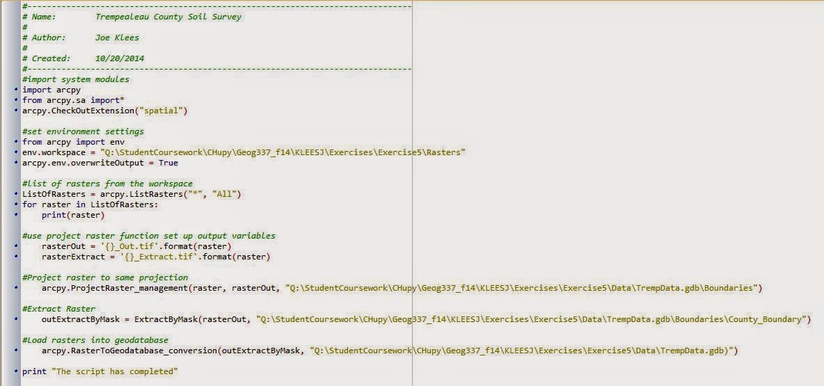
To put the data into a neat map I wrote a Python script which can be seen in the Python scripting blog post under exercise 5. This clipped the data into just the county of Trempealeau and projected the data into the correct projection. It also loaded the finalized feature class into the Trempealeau geodatabase. The resulting map is shown below, incorporating all of the downloaded data into one poster.


Data Accuracy – The table below shows parameters from the metadata for each of the separate data records that were downloaded.


Record
Scale
Effective Resolution
Minimum Mapping Unit
Lineage
Temporal Accuracy
Rail Lines
1:24000
30m
30m
US Department of Transportation
2014
NLCD
1:24000
30m
30m
USGS
2011
DEM
1:100000
10m
10m
USGS
2013
NASS
1:100000
30m
30m
USGS
2013
Trempealeau
1:24000
30m
30m
Trepealeau County Land Records
2014

(See Python Blog Post for Python potion of this exercise.)

Sources:

US Department of Transportation Bureau of Transportation Statisics Link
USGS National Map Viewer Link
USDA Geospatial Data Gateway Link
Trempealeau County Land Records Link
USDA NRCS Web Soil Survey Link

Python Scripting

Introduction - Python is used in writing scripts in ArcGIS to perform data analysis, therefore it is a very important skill to have in the GIS field. This post illustrates some of the skills I learned in writing Python script in my GIS II course.

Exercise 5 - October 20, 2014 - This script was written to project, clip, and load pre-downloaded data into a geodatabase. I input raster data from various website and the output was a clipped map of Trempealeau County in the proper projection and deposited into a pre-designated geodatabase.


Exercise 7 - November 12, 2014 - This script was written to select the active mines, that are not a rail loading station, and not within 1.5 kilometers of the railroads. We used mine and railroad data from DNR, not from our geocoding exercise. Once the script is complete we have a shapefile of the mines that meet the above criteria.


Exercise 8 - December 16, 2014 - This script was written to analyze the raster data that I created in exercise 8 and generate a weighted index model using Python. I first set up the variables, build n equation to weight one of the factors and add all the factors together.

The map below is the resulting raster from the completed python script with the residential being weighted in the overall index with the five suitability factors included.


Friday, October 3, 2014

Exercise 4 - Sand Mining for Hydraulic Fracturing

Introduction

Sand mining is a booming industry in Wisconsin today, and this is because of the increase in Hydraulic Fracturing or fracking that is going on across the country. Wisconsin has some of the best sand in the country and it is vital in the fracking technique. This post is an introduction to the project on sand mining we are doing in this GIS class and will continue throughout the semester.

What is fracking?

Fracking is the mining of natural gas using a hydraulically pressurized liquid full of water, sand, and many other chemicals and fracturing the natural gas contain rocks. This is practiced in areas that have an abundance of shale which is the most common location for natural gas to be stored naturally. The importance of sand mining in Wisconsin is evident in the vital inclusion of sand in the mixture that is used to fracture this shale. Even though the sand mining that is vital to the fracking process is from Wisconsin, fracking does not take place in Wisconsin even though there are some future potential candidates in the northern parts of the state. Rather, the states on the eastern and western coasts as well as southwestern U.S. have the best locations for fracking due to shale formations in these areas.

Where in Wisconsin is the sand mined?

There has been mining of sand in Wisconsin all the way back to the 19th century due the states abundance of the material. Most of the western part of the state is sandstone and the sand here is perfect for fracking because the quartz crystals that make up Wisconsin sand are the correct size and shape needed for fracking. The sandstone reaches from the northern counties of Washburn and Burnett all the way to the southern border of Illinois. The figure below shows the locations of sand mines in Wisconsin mostly focused in the western and central parts of the state. The university here in Eau Claire sits right in the middle of thickest sandstone deposit part of the state.

(fig 1)

Issues with fracking and sand mining

This topic of sand mining and especially fracking are very hot debate issues in the news today. There are issues with what effects there are on the environment when fracking is practiced in the area. Fracking has been related to water contamination, landslides, and other environmental health and safety risks. An article from the Washington Post this past month discussed a recent study that found fracking to increase reports in health problems. The report quotes local farmers near a fracking operation in Arkansas who said they had health problems related to the water they drank believing it to be contaminated by the local fracking. Meanwhile, the companies say that there is no correlation between fracking and public health concern, citing these studies as strictly opinion based polls. However, environmental public health researchers have found there to be some worry but not to make any connections until further research has been done.

How GIS will be used in this project

GIS is an important tool in analyzing spatial data and this can help us get a overview and predict patterns in the data. We can use GIS to map out current sand mines, transportation routes for moving the sand, and future potential mine locations.


Sources 

Robertson JM. 2012. Frac Sand Factsheet. Wisconsin Geological and Natural History Survey.


Wisconsin DNR. Industrial Sand Mining.

Wisconsin DNR. Silica Sand Mining